TAHMO

All posts in Uncategorized

Hi,

My name is Cyuzuzo Honore, a coordinator for TAHMO in Rwanda.

I had an idea of developing weather information service for student in Rwanda. The idea won me a grant.

It started at a challenging time in 2020: COVID-19 hit. In Rwanda, TAHMO activities (especially those that involved travelling) were disrupted. During the first months of COVID there was a lot of fear since only little information on the virus was available. But as days went by, these informations became available; we knew how to protect ourselves and eachother which reduced the fear we all felt at first. But still Rwanda – my country – was under travel restrictions.

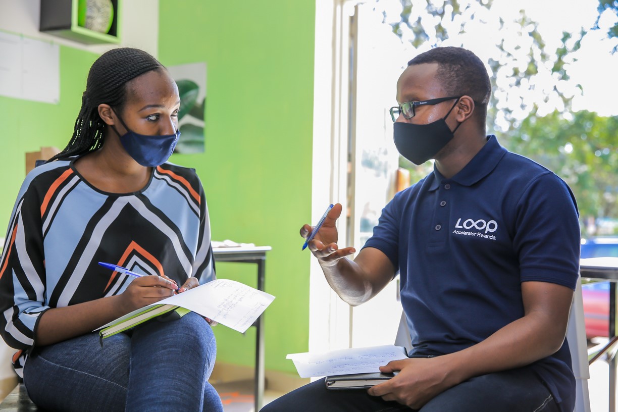
Mid-August I got to know about LOOP ACCELERATOR – an incubation program for Education Startups. I have long had a vision to improve climate literacy in the younger generation. With motivation from TAHMO’s SCHOOL – 2 – SCHOOL program, I envisioned developing a climate information platform. My Idea was to was to develop a portal with this information, then add some climate change mitigation and adaptation skills on the online platform that will be accessible to Rwandan schools.

Severe Weather Consult, TAHMO’s sister company in Rwanda, has a platform called iHEWA, whose goal is to enhance accessibility of weather information services. Among the targets of the platform are the students – they interact, learn and experiment local weather data which enhances their knowledge on climate change mitigation and adaptation. We strongly believe education is an essential element of the global response to climate change.

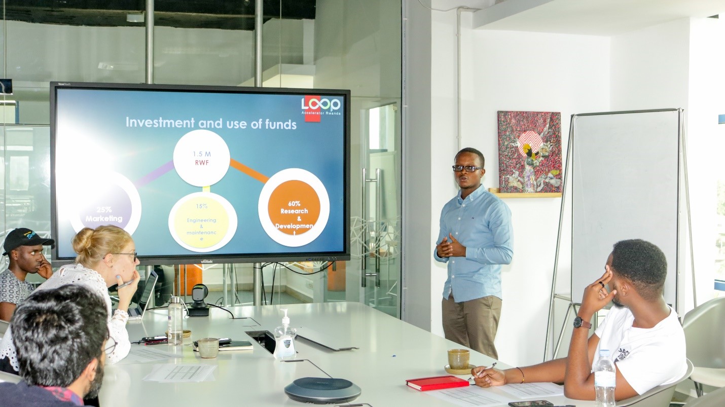
I submitted my concept and it won a grant. I spent 3 months in Loop accelerator. It was great opportunity to share experience with other more than 10 startups in Education including some already in the market. It was also a milestone to let Rwanda ICT Chamber, GIZ, SMART Africa get to know what we are doing as TAHMO in closing the gap by providing accurate and efficient Meteorological data. In addition, Loop accelerator grant us 800 USD in total that helped us develop IHEWA Online platform (click to visit ihewa).

IHEWA will be as online library for climate literacy for young generation to start act on climate change action plan. Also, IHEWA will be like a tool for schools while they are teaching climate change mitigation and adaptation. A vast online platform that will be including climate science lesson plans, climate change mitigation and adaptation skills and climate change risk reduction tips.


In the Lake Kivu region, water erosion is the main driver for soil degradation, but observational data to quantify the extent and assess the spatial-temporal dynamics of the controlling factors are hardly available. In particular, high spatial and temporal resolution rainfall data are essential as precipitation is the driving force of soil erosion. In this study, we evaluated to what extent high temporal resolution data from the TAHMO network (with poor spatial and long-term coverage) can be combined with low temporal resolution data (with a high spatial density covering long periods of time) to improve rainfall erosivity assessments. To this end, 5-minute rainfall data from TAHMO stations in the Lake Kivu region, representing ca. 37 observation years, were analyzed. The analysis of the TAHMO data showed that rainfall erosivity was mainly controlled by rainfall amount and elevation and that this relation was different for the dry and wet seasons. By combining high and low-temporal resolution databases and a set of spatial covariates, an environmental regression approach (GAM) was used to assess the spatiotemporal patterns of rainfall erosivity for the whole region. A validation procedure showed relatively good predictions for most months (R2 between 0.50 and 0.80), while the model was less performant for the wettest (April) and two driest months (July and August) (R2 between 0.24 and 0.38). The predicted annual erosivity was highly variable with a range between 2000 and 9000 MJ mm ha−1 h−1 yr−1 and showed a pronounced east–west gradient which is strongly influenced by local topography. This study showed that the combination of high and low-temporal-resolution rainfall data and spatial prediction models can be used to improve the assessments of monthly and annual rainfall erosivity patterns that are grounded in locally calibrated and validated data.

Read more                                                                  Download Pdf


Based in Chicago, Farm Immersive is a weekly blog by Peter Miller. His posts explore global food and agriculture innovations.

In a recent blog published on the 13th of April 2020, we got an honorary mention. In Peter Miller’s exact words TAHMO is a bold project to build weather stations across Africa and share that data free of charge. This will greatly enhance all crop insurance modeling across the continent”.

want to read more on this beautifully written piece? click here


With the global COVID-19 pandemic, activities have been highly slowed down. However, Victor in Kenya is trying to keep things moving. Being a field engineer, it is a bit complicated for him to work from home, but during this pandemic, he adjusts and finds ways to ensure that field activities do not stop completely especially for stations that need urgent maintenance - for the data, we lose today cannot be readily regained. Read more

COVID-19

Categories: Uncategorized
Comments: No

Due to the current COVID-19 situation, stations’ uptime might be affected. We are doing our best to maintain a very high uptime but remote stations could be affected due to restrictions on travel in these difficult times.

ENDEAVOR TO STAY SAFE
– Avoid public gatherings or crowds.
– Wash your hands with soap for at least 20 seconds when you come in from public areas or use an alcohol-based (more than 60%) sanitizer.
– If there are restrictions on movement in your locality, kindly heed them.
– Practice social distancing.


Vulnerability to Blue Tick will likely increase in the coming years in Laikipia County in Kenya unless stakeholders intervene. This is according to Peter Mbugua, a Geospatial Information Science and Remote Sensing student at Dedan Kimathi University in Nyeri, Kenya.

Influences of climate changes in the spatial and temporal variation of tick-borne diseases (TBD) are frequently overlooked by researchers. Consequently, there are no effective control strategies and measures to minimize the spread of TBDs. This results in the loss of livestock, lower productivity, decrease in human health and reduced income from (agro)tourism.

Peter has identified areas in Kenya for low, middle and high risk of TBD. Through using GIS-based Multi-criteria evaluation – including humidity, rainfall, temperature, wetlands, rivers, and slope of the county – Peter determined that the changing trends in weather patterns in the last 15 years continue to favor parasite survival. 

These results can be used to implement measures to counter the spread. For example, high-risk areas can be sprayed and pastoralists can be informed about farm &-livestock management to prevent the spread of tick-borne diseases.

**Written by Peter Mbugua


Commissioning of the ATMOS 41 Automatic Weather Station of TAHMO.
Commissioning of the ATMOS 41 Automatic Weather Station

To keep pace with the advancement in sensor design and technology on weather-related issues, the Vice-Chancellor of the Federal University of Technology, Akure, Professor Joseph Fuwape has commissioned a newly installed 4th Generation ATMOS 41 Automatic Weather Station (AWS) at the WASCAL Centre, FUTA. This is an upgrade of the 1st Generation Trans-African Hydro-Meteorological Observatory (TAHMO) Automatic Weather Station (AWS) which was installed at the WASCAL Meteorological Observatory at the Federal University of Technology, Akure in 2014 as the first TAHMO Station in Nigeria.

Continue reading…


The TWIGA Kumasi Hardware Hackathon

**Written by Nick van de Giesen
TAHMO has been working with the TWIGA project since the start of 2018. An important output of the TWIGA project will be new geo-services (twenty!) based on the application of innovative sensors. In order to speed up the development of these services, a Hackathon was organized from 19 through 23 November 2018 at the Kwame Nkrumah University of Science and Technology in Kumasi Ghana. The objective was to build complete value chains, from observation to internet storage to service delivery. We aimed high on purpose to see what can and cannot be done in such a short time. The results are very promising! Continue reading on the TWIGA website…

TWIGA hackathon participants showing their environmental weather innovations.
TWIGA Hackathon participants showing their innovations!