Open-source non-contact river flow observations with cameras for Africa
The objective of this project is to establish an open-source platform-independent hardware and software workflow to establish new operational river monitoring sites through image velocimetry methods derived in our consortium, based on simple camera hardware. This technology so far is only available within a limited number of commercial firms with proprietary solutions and thus not accessible in low income countries. Through our workflow we facilitate that new sites can be established both in high income and low income countries, with conventional and easily accessible camera hardware, and without any specific requirement for processing hardware (web-based). Developments in this project focus on the software for derivation and maintenance of rating curves and API connections. We will implement the project through co-design with our first users in the consortium, development and testing at locations in Tanzania and The Netherlands, and through training with local users. We propose a solution which is easily scalable.
Describing the Observation Technology :
We will develop a fully open-source, user-friendly, low cost and sustainable hardware and web-software stack with API to establish and maintain river rating curves (relationships between geometry and river discharge)in small to medium sized streams based on our prior experience in studies with test sites in Zambia and Tanzania. The hardware/software stack willallow a practitioner in hydrology anywhere in the world to monitor and maintain rating curves with a simple staff gauge, a simple camera (can be a smartphone) and simple survey equipment without any costs for software. It will be a locally deployable service (laptop, desktop, local server or cloud), with local people, local devices and open software leading to job creation and locally sustainable services for NMHSs and their service providers.Different from the few existing commercial solutions, we offer the following innovation:
Sustainability perspective
• A low-cost hardware solution to survey the river section of interest, using a low-cost dual frequency GNSS solution, that we have gained a wide expertise with. • Open-source software under GPLv3 license, deployable via a docker image, as a web-interface on local hardware, or (as a service) on our own cloud service. • No requirement for use of specific camera platforms (a smart phone camera can work just as easily as a full IP webcam). • An open architecture API to store, review and further analyze the data.
Technical perspective
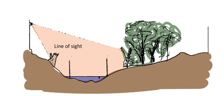
•Physics based principles to estimate flows in parts of the AOI that are obscured, e.g. by shading or vegetation. Therefore, the solutions can be used in non-ideal locations (see e.g. Figure 1) •Uncertainty estimates on rating curves based on variance in velocity estimates and uncertainty in vertical velocity profiles. •Rating curve updating based on one event only. So under changing conditions, rating curves can rapidly be updated.
Therefore, the software stack can be used in low-resource settings, by e.g. NMHSs or local enterprises offering services to governmental agencies, consultants, NGOs that require establishment of flow observation sites. The API will be set-up such that in a later project, live feeds can be operationally processed into flow estimates as well.
Figure 1. Schematic of non-ideal site location at Chuo Kikuu –Dar esSalaam. We deal with shading and partly obscured images. Schematic by Gerben Gerritsen MSc.