TAHMO

News

photos and text: Matti Barthel (ETH Zurich, Department of Environmental Systems Science)

CBO and TAHMO cooperate in the DRC

Three years ago, we – researchers of the Congo Biogeochemistry Observatory (CBO) – got in contact with TAHMO to install weather stations at our field research sites in the Democratic Republic of Congo (DRC). Generally, basic weather data is an important pillar to conduct environmental research, which in our case mainly focuses on the biogeochemical cycling of carbon and nitrogen within the agricultural and forest systems of the Congo Basin. Until recently, the DRC was a white spot on the TAHMO network map and had, in general, poor weather station infrastructure.

Now, the data obtained from the TAHMO network provides unique, continuous, high-resolution data necessary to help unravel the complex processes of carbon and nitrogen cycling that in turn are important players in global climate through the release and uptake of greenhouse gases. Over the course of the last three years, we successfully installed nine stations, which now provide continuous data in quasi-real-time. For us as researchers, this is an invaluable source of information that is readily at hand, especially when we talk about remote locations like the DRC. These stations were installed in strategically located regions in an effort to provide a representative and accurate estimate of climatic variables for our field sites.

Weather data for soil preservation

For example, five of the stations were installed around Lake Kivu in Eastern Congo, a region world-famous for the gorilla populations roaming the opulent and steep volcanic mountains of Virunga and Kahuzi-Biéga National Parks. Of these five stations, three are maintained by the Observatoire Volcanologique de Goma (North Kivu) and two by the Université Officielle de Bukavu (South Kivu). One of the major environmental problems of the Kivu region is increased soil erosion due to human activities such as mining and agriculture. One of the most important drivers of soil erosion is precipitation, which – falling on the steep terrain with fragile soils – results in enormous amounts of sediment exported causing flash floods and a massive amount of soil loss. These land uses become particularly deleterious because of the combination of steep terrain and high levels of precipitation common in the region. The data of the stations close to Goma are therefore used by Montfort Balgawa Rukeza, a Ph.D. student at the Catholic University of Louvain, to understand the seasonal export dynamics of suspended fine sediment through rivers as a result of the increased soil erosion driven by rainfall and land use choices.

Further, two more stations were installed in the heart of the DRC, in the Tshopo province, of which one is installed at the Campus of the Université de Kisangani and the second at the former Belgian research station at Yangambi (see picture). This part of the Congo Basin probably reflects best what people imagine when thinking of the Congo: endless green, dense, impenetrable forests, interrupted only by the mighty Congo River and its tributaries.

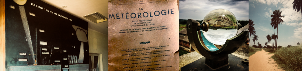
Figure 1: Impressions from the Yangambi meteorological office: Scheme of inside the hallway with the title ‘Bilan d’energie et bilan d’eau d’une couverture vegetale’ [energy balance and water balance of a vegetation cover]; old magazine on meteorology found in the local library; Campbell-Stokes sunshine recorder; local street (from left to right).

The weather station installed in Yangambi, on the banks of the Congo River, is to me, personally, the most valuable of all currently running stations in the DRC. This has two reasons. First, the European Commission, together with the University of Ghent, is currently establishing a micrometeorological greenhouse gas flux tower in the dense and lush tropical forest surrounding Yangambi (Congoflux) to monitor energy and greenhouse gas exchange between the forest and the atmosphere. The data generated by the TAHMO Yangambi weather station will deliver important preliminary data mainly related to wind speed and direction, which can provide critical information for the setup of the tower (flux footprint).


The second reason is related to the static analog archives of past weather conditions recorded manually at Yangambi. This dataset dates back to 1905 and was maintained and assembled by the Institut National pour l’Etude Agronomique du Congo Belge (INEAC) and later continued by the Institut National des Etudes et de Recherches Agronomiques (INERA). Emmanuel Kasongo Yakusu, who is a lecturer at the Université de Kisangani and also a PhD student at the University of Ghent and the Musée Royal de L’Afrique Centrale in Belgium, went through the massive task of digitizing this huge dataset, which covers now several decades into the past. Part of his work involves analyzing the recent climate change at the local (Congolese intact forest, Yangambi) and regional scale (Congo Basin). His overarching thesis objective concerns forest management of the Congo Basin facing climate change, particularly investigating the impact on the economically valuable tree genus Entandrophragma. Since the meteorological office at Yangambi is still measuring and continuing this dataset it is now very exciting to compare their analog measurement methods, which are still the same as 100 years ago, with the recordings of our TAHMO weather station. Comparing the TAHMO station with analog measurements.

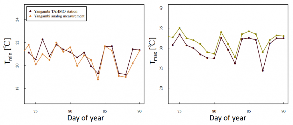
Figure 2: Two weeks of daily minimum (left panel) and maximum (right panel) temperatures recorded at Yangambi meteorological office measured with TAHMO (black) and conventional analog devices (colored).

Figure 2 shows an evaluation over two weeks of temperature data recorded with the TAHMO weather station compared to the temperature taken with the analog methods of the Yangambi meteorological office. This comparison nicely illustrates how a combination of different datasets can verify and validate the traditional measurement techniques employed at Yangambi to better explore the wealth of information hidden in this inherited treasure.

Cooperation to monitor meteorological data across the DRC.

The last two stations of our growing network were recently installed in the very south of the DRC close to the city of Lubumbashi, within a landscape dominated by enormous termite mounds scattered in between the vast Miombo woodlands. In sum, the building relationship between TAHMO and CBO has greatly improved our ability to continuously monitor meteorological data across the DRC by covering various climatic zones including montane rainforests in the east, dense lowland forests in central Congo and woodland savannah in the south. Further, it provides the lecturers at the local universities with an excellent tool for their classes in fields like hydrology, meteorology, pedology or ecology just to name a few.


One of the challenges of the Ghana Meteorological Agency (GMet) is the availability of real-time weather data for its day-to-day activities such as daily weather monitoring and forecasting, climate monitoring, etc. It takes about a month for data from the manual observatories to get to the central collation point for digitization, quality control and archiving. GMet believes the deployment of automatic weather stations (AWS) is the best way to resolve this challenge. Following the partnership with the Trans-African Hydro-Meteorological Observatory (TAHMO), GMet has inched a step closer to achieving these results and improving its service delivery.
The TAHMO AWS network has complemented the GMet station network thereby improving the spatial resolution of the GMet data. This has helped GMet in generating gridded datasets of temperature and rainfall by merging the gauge data with satellite rainfall estimates and reanalyses data. In terms of data quality, the data have shown consistent correlation with the GMet observatories within close proximity of the TAHMO stations and for that reason used as reference stations for quality controlling the observed data.
It has also made available real-time data for weather monitoring and forecasting thereby improving the operational work of the forecast office.
Overall the TAHMO project has been of great benefit to both GMet and Ghana as a whole and this has reinforced the decision by GMet to roll out its AWS program.

**Written by Kwame Duah.


TAHMO has received two small business development grants under the SBIR program of the Netherlands government. The first grant concerns the development of an agronomic advice service for potato farmers in Rwanda. It is a cooperation between Severe Weather Consult, a Rwandan SME, and TAHMO. Potato farmers in Rwanda tend to spray a lot, especially to avoid a disease called Late Blight. It seems they are actually spraying too much and the service will provide advice as to when it is necessary to spray and when not. Information is provided by Apps4Agri, a Dutch SME, which provides input from their advisory system, while TAHMO/SWC provides the data concerning the climate to determine if the Late Blight pressure is high enough to warrant spraying.

The second project concerns a warning system for the onset of the rainy season in West Africa, particularly in Ghana’s northern regions. Often, rains occur early in the year which seems to be the start of the rainy season but are actually spurious rains that are followed by a drought of more than 10 days. When farmers sow after these first rains, they will lose their seed. By using a mix of TAHMO and satellite data, we can determine whether or not the real rainy season has started and warn farmers in case of a false start. This may also be used to build germination insurance. We will work together with the Ghana Agricultural Insurance Pool and Farmerline, two partners within the TWIGA project, and the Savanna Agricultural Research Institute (SARI). In this movie, Dr. Alhassan Lansah Abdulai of SARI explains the need for such a warning service. Full video here.


SARI’s Dr. Alhassan Lansah Abdulai


The School-2-School Team would like to highlight two schools as the winners of the S2S September Challenge. Namanga Mixed Secondary School and Kibisi Secondary School have been exceptional in their monthly TAHMO station cleaning and using the weather data in their classroom.

  • Namanga Mixed Secondary School has focused on temperature and wind speed & direction data from their TAHMO station. Students have learned how to calculate the daily mean temperature and the daily temperature range. Using the wind speed and direction data, students have learned how to draw wind rose to show the distribution of wind directions
  • Kibisi Secondary School has involved their students and geography club in cleaning their TAHMO Station. During a routine cleaning, students noticed that the rough middle surface (splash guard) was very dirty. They used their problem-solving skills and found a method to clean it using a toothbrush without interfering with the glass plate or the temperature sensor. The students have learned how important maintaining a clean weather station is to recording accurate results. The teacher in Charge Mr. Edalia Wycliffe uses the data in his classroom and has taught his students how to download the data from the School-2-School website. He uses the data in spreadsheet form to calculate mean, mode, range, and standard deviation and says using real data has enriched his classroom lectures

Gilbert attended the weather event indaba hosted by Deutsche Gesellschaft für Internationale Zusammenarbeit (GIZ) GmbH, the Make-IT in Africa, Agency for Business & Economic Development (AWE) and Strathmore University (@iLabAfrica) to explore the potential of integrated digital solutions in Agriculture. It aimed at exploring ways of using technology such as IoT and AI we aim to make life better for those who produce our daily food – the small-scale farmers and their families

Various participants from agricultural organizations, financial and insurance companies, tech start-ups, and government agencies were hosted. Gilbert demonstrated the TAHMO API and how it would contribute to improving the weather value chain in Africa.

At the end of the workshop, participants engaged in design thinking and developed possible solutions that agricultural communities, innovative start-ups, and tech communities can work together to bleach various challenges in the agriculture chain. On the sideline, Gilbert held meetings with the team of IBM Germany.


TAHMO hosted two workshops on user engagement one for the TAHMO internship and the other for users of the data on the 25th and 27th of August respectively. On the internship workshop, 18 graduates who recently joined our TAHMO internship program attended an induction meeting held at KMD, hosted by Gilbert and also facilitated by Frank( TAHMO CEO) and David Mburu (Director of Training school at KMD). Dirk V.O. Lubbe and Els Veenhoven also contributed to the workshop.

 It was an opportunity for interns to know how TAHMO operates, the challenges we want to solve, and how they would be involved. The internship program will challenge participants to solve a wide range of problems in the meteorological industry – from mapping users’ needs, big data management, station network management, school-to-school programs, and the development of business with weather data.  I am looking forward to reading lots of stories about what each one of them will be doing.

 Follow what the interns are up to on the link: https://sites.google.com/view/tahmointernship

On August 27th, TAHMO and KMS co-organized a workshop on Environmental sensor market research. over 50 participants ranging from Farmers, Universities, and private and public institutions attended.

TAHMO attended the 2nd RCMRD International Conference which was organized from the 15th to the 17th of August, 2018. Here, stakeholders from across Africa came together with ideas on how to fast-track applications for earth observations and geo-information technologies and discussed how to implement these into decision-making processes.

During the open-panel discussion, TAHMO shared its vision and experience on the importance of institutional collaboration.


The TAHMO Initiative regards training and education of both teachers and students of schools with a TAHMO station as a very crucial ingredient of the Initiative. This is done through the school2school program which is created to serve the important purpose of educating, training, and support with teaching and learning materials.

Students and Geography teachers of St. Paul’s SHS, Denu in the Volta Region of Ghana had an interactive session to understand TAHMO’s school2school program. The students joined Mr. Kwame Anhwere – the TAHMO regional coordinator – to carry out maintenance work and understand all the ins and outs of the weather station. This attracted students from other departments who found the session quite interesting.

During the sessions, the main discussion was about how the environment supports life and the importance to take good care of it. It was about the activities and responsibilities that individuals and governments have to minimize their impact on the environment. The last part of the discussion centered on the various sensors on the station, how they work, the parameters being measured, and how data could be accessed and visualized for lesson plans.

The students had the opportunity to see the real-time measurements when the station (logger) was connected to the computer as well as near real-time measurements online via the school2school.net platform. Some of them had the opportunity to check the data online.

The school expressed its appreciation and was happy to be among the selected schools in the country to host a TAHMO station.


**Written by Kwame Duah**