TAHMO

All posts in Weather Stations

With climate change increasing its mark on all aspects of the hydrological cycle, societies all over the world living in flood-prone areas are increasingly exposed to flood hazards. In many parts of the world,
especially in less developed areas, societies lack knowledge and data to predict future flood events.

By predicting a future flood event, an organization creates a time frame to implement a mitigating action that reduces the financial damage inflicted. In recent years, the development of new measuring techniques has significantly lowered the cost of collecting data and information on different aspects of the hydrological cycle.

These developments enable organizations in regions restrained of knowledge and data to establish methods to analyze aspects of the hydrological cycle, thereby predicting the probability of a flood hazard several hours or days in advance. This thesis explores various possibilities for designing and implementing an Early Warning System (EWS) for the Bus Rapid Transport System (BRT) in Dar es Salaam.

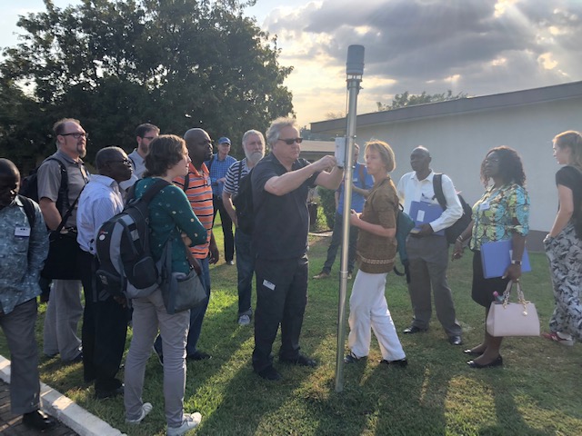
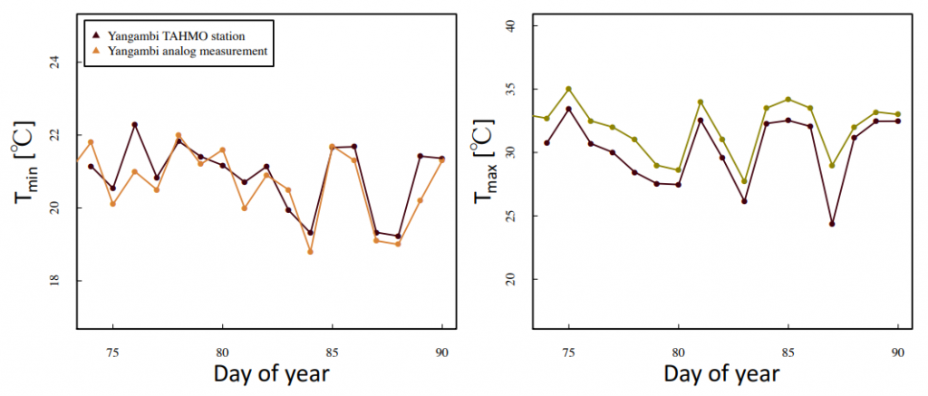
The EWS design is based on the forecasting requirements, investigated with the BRT-system. Several operational forecasting methods are available. The EWS designed in this thesis makes use of rainfall data obtained from rainfall stations located in the Dar es Salaam region, installed and managed by the Trans-African Hydro-Meteorological Observatory (TAHMO).MoreFinal_Thesis_Markus_Pleij_4238001


Every year on the 3rd March the world commemorates World Wildlife Day. We celebrate the wide diversity of animals and plants across the globe while raising awareness about threats facing them.

This year’s theme, “Life below water: for people and plants” is inspired by goal 14 of UN sustainable goals which aims to conserve the oceans while also sustainably extracting resources from within them. TAHMO is one of many initiatives contributing to the wildlife and water agenda.

TAHMO has installed 10 stations within 22 km of the Kenyan coastline, and distributed along the entire coastline. In all national parks, you will find a TAHMO weather station with close range.  Shimba Hills National Park hosts one of many TAHMO stations in Kenya. There are 9 stations close to Maasai Mara national park, 11 stations circling Mount Kenya national park, 5 stations near Aberdare national park, 2 stations near Chyulu national park and the list continues. Initiatives like the Maasai Mara citizen observatory and TWIGA, which TAHMO is part of, will contribute to the sustainability of wildlife.

TAHMO stations on Kenya’s Coastline. Source

We understand the world today is seeking better ways to conserve and sustainably use the forests, oceans, seas and marine resources for sustainable development and weather data is a critical component of it. Are you working in the wildlife conservation sector and in need of weather data? Reach us at: info@tahmo.org.

Written by Gilbert. Twitter: @mwangilbert


The idea of TAHMO started back in 2010/2011 and was formalized through a foundation in 2014. Since 2014 the organization managed to install over 400+ weather stations across 20 African countries. An amazing achievement. However, this did not go as simple as an ABC. Through this blog, we would like to lift the curtain on some of the challenges that we faced throughout the years. Perhaps you – our reader – are able to come up with suggestions or ideas to smoothen the challenges that we face up ahead.

So here come the six challenges that TAHMO faces.

Administrative challenges

Have a partnership agreement with national metrological agencies. Every country has a different administrative structure. Countries differ in the way they do business and set up collaboration programs. How do you share data? Who gets it first? How do you share costs and revenues? Who does the maintenance? All these questions need to be answered before you can operate in the area of a governmental agency.

Find an experienced local host who is available in the case of station maintenance. The training that one has to give a local host depends on various factors. Like is the host staying in the area for the long term? We create a shared responsibility by providing the local host with access to the weather data. This is how the school2school platform was set up. This resulted that most of the local hosts being teachers. Consequently, with 400+ weather stations, this means that a lot of hosts are needed which puts the strain on good & quality relationship management with each host.

Economic challenges

Weather stations are not free. Funding is needed to buy the stations and put them in the right location. We have to pay for the installation and maintenance of each station. Now, here is a little eye-opener: the larger your infrastructure, the more money you have to pay for your maintenance. And maintenance is not always easy. Some weather stations might be right around the corner. But sometimes you must drive up a full day for a quick fix. And although our weather station is the most robust weather stations out there, that does not guarantee a maintenance-free infrastructure. Leaves can get into the funnel, sensors might stop working, or perhaps a tree has overgrown near our weather station, influencing the data.

Equipment challenges

Everywhere we go, we find a different setting with different conditions. The access to the site might be bad, there are safety concerns of theft of our weather stations and more. Sensors might stop working, a hardware update might deplete the batteries and if the station is not regularly cleaned, it will influence the data and even might stop working. For this reason, we promote the cleaning of our stations through our social media. To create awareness that infrastructure should be regularly maintained.

Data Sharing Challenges

The TAHMO weather stations collect data. But with big data, comes great responsibility. With whom do we share this data? What do our partners want to do with it? Should we give it to other governmental institutions like housing or the military? Could our data be used to harm people or minorities? These questions are of major importance which have – most of the time – no clear answers. 

Setting up the infrastructure has not been easy. But with the help of our partners, researchers, enthusiast, volunteers, and our great team, we’ve managed to install 400+ weather stations in 20 countries. A great success.

Do you have ideas on how to help TAHMO? Please share them by sending an email to info@tahmo.org

**Written by Theophile Mande & Friso Vos de Wael


TWIGA partners together in Ghana for the TWIGA days
TWIGA partners together in Ghana!

The first week of the TWIGA days consisted of meetings, workshops, and conferences. The first day (Monday) consisted of updates from all the TWIGA partners about the progress made in the previous period. All updates about the projects that have been completed and are still in the developing stage and problems that have occurred have been included.

The Tuesday consisted mostly of workshops. Here, the TWIGA partners split up into three groups; biosphere; hydrosphere and atmosphere. In these workgroups, the partners discussed various new services that could be developed. They made a feasibility and cost analysis and then chose one of the possible services to discuss further.

Develop business models for TWIGA services.
TU Delft students chair a meeting to develop business models for TWIGA services. 

The resulting services which were derived from this workshop are:

  1. Improved insurance for farmers with weather data
  2. Advice for potatoes and cocoa spray
  3. Solar power generation
  4. Early warning system for flooding

The students will focus their internship on the development of these business models for these services in the upcoming months. 

On Wednesday the group participated in a user needs assessment workshop with local farmer-& agribusiness representatives. For this workshop, the team split up again and gave advice about how a user’s needs can be identified with the Business Model Development method. This workshop was held to identify the farmer’s needs and the agribusinesses’ needs, with these needs, the corresponding services that TWIGA could deliver were identified. The user needs assessment revealed that services are required, but that facilitating these services is very expensive and might not provide the desired result that the farmers would want. Also, the needs of farmers and agribusinesses match quite well, both would benefit from a lot of services. Interestingly was that the users mentioned that they need education and capacity building in farm management knowledge. For example, it is greatly beneficial if a user knows when and how much fertilizers or pesticides need to be applied. This need can go hand-in-hand with the weather services that TWIGA provides. Since the leaching of fertilizers or pesticides correlates with the weather.

Visiting farmers, weather stations and flooded areas in and around Kumasi

On Thursday the TWIGA partners stretched their legs on a field trip. The weather station was right on the campus of KNUST (Kumasi University). Continuing to the next weather station at a palm oil plantation where soil moisture sensors were included. 

After these visits were made, all the partners visited a flood site, a bridge over a river in the neighborhood of Aboabo, where many floods take place on a yearly basis. In this situation, the risks and health hazards of floods could also be identified. The floods and blocked drains in the neighborhood made many houses filled with water on the bottom, like in the picture below. This has made numerous houses uninhabitable and the stagnating water in the area becomes a breeding spot for mosquitos and vector-borne diseases. 

Flooding affected a local mosque in Kumasi.

Lastly,  the group visited a farm, to inspect it for possible placement of a soil moisture sensor (a cable covering the entire field). This sensor can measure which parts of the farmland are in need of moisture or fertilizers, aiding in the efficiency of farming. A great additional benefit to the TWIGA services.

All in all, the TWIGA days illustrated the great need there is for weather services. Looking forward to the next partner meeting!

**Written by Roxana Vafa, Rosalie Middendorp & Anne Schermerhorn. Students of the Delft University of Technology. 


The TWIGA Kumasi Hardware Hackathon

**Written by Nick van de Giesen
TAHMO has been working with the TWIGA project since the start of 2018. An important output of the TWIGA project will be new geo-services (twenty!) based on the application of innovative sensors. In order to speed up the development of these services, a Hackathon was organized from 19 through 23 November 2018 at the Kwame Nkrumah University of Science and Technology in Kumasi Ghana. The objective was to build complete value chains, from observation to internet storage to service delivery. We aimed high on purpose to see what can and cannot be done in such a short time. The results are very promising! Continue reading on the TWIGA website…

TWIGA hackathon participants showing their environmental weather innovations.
TWIGA Hackathon participants showing their innovations!

photos and text: Matti Barthel (ETH Zurich, Department of Environmental Systems Science)

CBO and TAHMO cooperate in the DRC

Three years ago, we – researchers of the Congo Biogeochemistry Observatory (CBO) – got in contact with TAHMO to install weather stations at our field research sites in the Democratic Republic of Congo (DRC). Generally, basic weather data is an important pillar to conduct environmental research, which in our case mainly focuses on the biogeochemical cycling of carbon and nitrogen within the agricultural and forest systems of the Congo Basin. Until recently, the DRC was a white spot on the TAHMO network map and had, in general, poor weather station infrastructure.

Now, the data obtained from the TAHMO network provides unique, continuous, high-resolution data necessary to help unravel the complex processes of carbon and nitrogen cycling that in turn are important players in global climate through the release and uptake of greenhouse gases. Over the course of the last three years, we successfully installed nine stations, which now provide continuous data in quasi-real-time. For us as researchers, this is an invaluable source of information that is readily at hand, especially when we talk about remote locations like the DRC. These stations were installed in strategically located regions in an effort to provide a representative and accurate estimate of climatic variables for our field sites.

Weather data for soil preservation

For example, five of the stations were installed around Lake Kivu in Eastern Congo, a region world-famous for the gorilla populations roaming the opulent and steep volcanic mountains of Virunga and Kahuzi-Biéga National Parks. Of these five stations, three are maintained by the Observatoire Volcanologique de Goma (North Kivu) and two by the Université Officielle de Bukavu (South Kivu). One of the major environmental problems of the Kivu region is increased soil erosion due to human activities such as mining and agriculture. One of the most important drivers of soil erosion is precipitation, which – falling on the steep terrain with fragile soils – results in enormous amounts of sediment exported causing flash floods and a massive amount of soil loss. These land uses become particularly deleterious because of the combination of steep terrain and high levels of precipitation common in the region. The data of the stations close to Goma are therefore used by Montfort Balgawa Rukeza, a Ph.D. student at the Catholic University of Louvain, to understand the seasonal export dynamics of suspended fine sediment through rivers as a result of the increased soil erosion driven by rainfall and land use choices.

Further, two more stations were installed in the heart of the DRC, in the Tshopo province, of which one is installed at the Campus of the Université de Kisangani and the second at the former Belgian research station at Yangambi (see picture). This part of the Congo Basin probably reflects best what people imagine when thinking of the Congo: endless green, dense, impenetrable forests, interrupted only by the mighty Congo River and its tributaries.

Figure 1: Impressions from the Yangambi meteorological office: Scheme of inside the hallway with the title ‘Bilan d’energie et bilan d’eau d’une couverture vegetale’ [energy balance and water balance of a vegetation cover]; old magazine on meteorology found in the local library; Campbell-Stokes sunshine recorder; local street (from left to right).

The weather station installed in Yangambi, on the banks of the Congo River, is to me, personally, the most valuable of all currently running stations in the DRC. This has two reasons. First, the European Commission, together with the University of Ghent, is currently establishing a micrometeorological greenhouse gas flux tower in the dense and lush tropical forest surrounding Yangambi (Congoflux) to monitor energy and greenhouse gas exchange between the forest and the atmosphere. The data generated by the TAHMO Yangambi weather station will deliver important preliminary data mainly related to wind speed and direction, which can provide critical information for the setup of the tower (flux footprint).


The second reason is related to the static analog archives of past weather conditions recorded manually at Yangambi. This dataset dates back to 1905 and was maintained and assembled by the Institut National pour l’Etude Agronomique du Congo Belge (INEAC) and later continued by the Institut National des Etudes et de Recherches Agronomiques (INERA). Emmanuel Kasongo Yakusu, who is a lecturer at the Université de Kisangani and also a PhD student at the University of Ghent and the Musée Royal de L’Afrique Centrale in Belgium, went through the massive task of digitizing this huge dataset, which covers now several decades into the past. Part of his work involves analyzing the recent climate change at the local (Congolese intact forest, Yangambi) and regional scale (Congo Basin). His overarching thesis objective concerns forest management of the Congo Basin facing climate change, particularly investigating the impact on the economically valuable tree genus Entandrophragma. Since the meteorological office at Yangambi is still measuring and continuing this dataset it is now very exciting to compare their analog measurement methods, which are still the same as 100 years ago, with the recordings of our TAHMO weather station. Comparing the TAHMO station with analog measurements.

Figure 2: Two weeks of daily minimum (left panel) and maximum (right panel) temperatures recorded at Yangambi meteorological office measured with TAHMO (black) and conventional analog devices (colored).

Figure 2 shows an evaluation over two weeks of temperature data recorded with the TAHMO weather station compared to the temperature taken with the analog methods of the Yangambi meteorological office. This comparison nicely illustrates how a combination of different datasets can verify and validate the traditional measurement techniques employed at Yangambi to better explore the wealth of information hidden in this inherited treasure.

Cooperation to monitor meteorological data across the DRC.

The last two stations of our growing network were recently installed in the very south of the DRC close to the city of Lubumbashi, within a landscape dominated by enormous termite mounds scattered in between the vast Miombo woodlands. In sum, the building relationship between TAHMO and CBO has greatly improved our ability to continuously monitor meteorological data across the DRC by covering various climatic zones including montane rainforests in the east, dense lowland forests in central Congo and woodland savannah in the south. Further, it provides the lecturers at the local universities with an excellent tool for their classes in fields like hydrology, meteorology, pedology or ecology just to name a few.


One of the challenges of the Ghana Meteorological Agency (GMet) is the availability of real-time weather data for its day-to-day activities such as daily weather monitoring and forecasting, climate monitoring, etc. It takes about a month for data from the manual observatories to get to the central collation point for digitization, quality control and archiving. GMet believes the deployment of automatic weather stations (AWS) is the best way to resolve this challenge. Following the partnership with the Trans-African Hydro-Meteorological Observatory (TAHMO), GMet has inched a step closer to achieving these results and improving its service delivery.
The TAHMO AWS network has complemented the GMet station network thereby improving the spatial resolution of the GMet data. This has helped GMet in generating gridded datasets of temperature and rainfall by merging the gauge data with satellite rainfall estimates and reanalyses data. In terms of data quality, the data have shown consistent correlation with the GMet observatories within close proximity of the TAHMO stations and for that reason used as reference stations for quality controlling the observed data.
It has also made available real-time data for weather monitoring and forecasting thereby improving the operational work of the forecast office.
Overall the TAHMO project has been of great benefit to both GMet and Ghana as a whole and this has reinforced the decision by GMet to roll out its AWS program.

**Written by Kwame Duah.


The TAHMO Initiative regards training and education of both teachers and students of schools with a TAHMO station as a very crucial ingredient of the Initiative. This is done through the school2school program which is created to serve the important purpose of educating, training, and support with teaching and learning materials.

Students and Geography teachers of St. Paul’s SHS, Denu in the Volta Region of Ghana had an interactive session to understand TAHMO’s school2school program. The students joined Mr. Kwame Anhwere – the TAHMO regional coordinator – to carry out maintenance work and understand all the ins and outs of the weather station. This attracted students from other departments who found the session quite interesting.

During the sessions, the main discussion was about how the environment supports life and the importance to take good care of it. It was about the activities and responsibilities that individuals and governments have to minimize their impact on the environment. The last part of the discussion centered on the various sensors on the station, how they work, the parameters being measured, and how data could be accessed and visualized for lesson plans.

The students had the opportunity to see the real-time measurements when the station (logger) was connected to the computer as well as near real-time measurements online via the school2school.net platform. Some of them had the opportunity to check the data online.

The school expressed its appreciation and was happy to be among the selected schools in the country to host a TAHMO station.


**Written by Kwame Duah**