TAHMO

All posts in Weather Stations

Turkana County is one of the counties in the former Rift Valley Province of Kenya. This is the second largest County in Kenya and it borders Uganda to the west and South Sudan and Ethiopia to the North.
15th January 2018 marked the start of a long journey of weather data collection by installing the first TAHMO Automatic Weather Station in the County, the first station was installed in Talent High School. TAHMO has up to now installed three Automatic weather stations in the County, Loima Boys High School, Talent High School, and Moi High School Kalokol.

On 5th July 2018, we received a ZL6 data Logger in Kenya. I decided to test the logger in areas with poor cellular network connectivity. My top priorities were Isiolo Meteorological offices where we have a TAHMO weather station and Loima Boys High School which is one of the sites in Turkana County. The first test was carried out at Isiolo Meteorological offices on 14th August 2018. The test was successful and the logger had a good network reception.

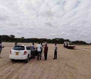
The station at Loima Boys High School had problems uploading data due to a weak cellular network. On 21st August 2018, I started a five-day journey to Turkana County, my aim was to bring the station at Loima Boys High School online again, test the ZL6 Logger and update the ATMOS firmware for all three stations in the county. I was very much committed to bringing the station at Loima online without moving it to a different location, I carried other local Sim-cards to the sites which I would use just in case the Vodafone Sim-Card failed. In my email conversation with Safaricom (network provider), they suggested we move the station to Lorughum where they have a 3G booster. So if all came to worse and the station failed completely, we would move the station to Turkana Girls High School which is near Lorghum 21 km away from Loima Boys High School. This means we would treat the weather data completely differently from that at Loima since these sites are far from each other.

Lodwar is the main town in the county, most people would come back to this town to spend their nights here after carrying out field activities in the remote villages. Loima Boys High School is located about 70km west of Lodwar town, this meant a 70 km drive on a large extensive semi-arid land. The best service you can do to yourself here is to take a lot of water. Sometimes we could drive for three hours before reaching Loima because the roads are covered by sand and the driver had to carefully choose the routes to follow otherwise the car could sink its tires into the sand.

The tricky part was crossing River Turkwel, here you have to get out of the car to reduce the weight of the car so that it doesn’t sink into the sand. At some point, we could push the car from behind to accelerate it so as to reduce the chances of it sinking. The best thing about crossing River Turkwel was that you meet several people who are also struggling to cross the river, you exchange ideas and some would tell you their mission in the county and their experience with the local communities.


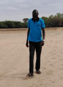
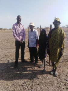
We met a young boy who offers guidance to people who have issues crossing the river, he says, “If you want to successfully cross the river, you drive parallel to the flow of the river, in case you notice where the sand is well compressed and firm enough, tilt the tires slowly by slowly till you reach the other end.” This trick was successful for the four times we crossed the river.


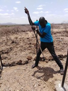
The time we spend crossing the river gave me some ideas on how to deal with the local community. I was well prepared with everything I needed to bring the station at Loima Boys High School online, but the experience at the river gave me a very different view of things, how you deal with the community can help you find a solution quickly or make it completely impossible. So we decided to stop at Turkana Girls (where we would bring the station too if it completely failed to broadcast at Loima) to do some tests. Here we meet the gateman, I explained to him that we intend to move the station here because at Loima the network is very weak, I also told him that the site at Loima is built on higher ground within the school compound, and we really would wish to keep the station within Loima and not move it as far as Turkana girls. He listened to me carefully and he had this to say “If you really want to retain the station in Loima, you have to move it towards a lower ground within the compound, network in this region seems to be stable on the lower grounds than higher grounds.” I doubtingly agreed to this, so we drove to Loima, I removed the station from the middle pole and moved to the lower ground within the school compound, I carried out a communication test and it was successful.

I talked to the School principal and asked for permission to move the station to the lower ground about 100 meters from where it was as long it will not interfere with the School’s future infrastructural developments.


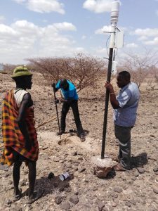
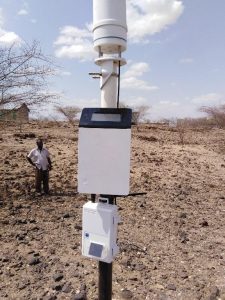
He agreed and we moved the station, I placed the ZL6 Logger and the EM60G logger on one pole. I set the upload frequency for the ZL6 Logger to be four data uploads per hour and that for EM60G to be one data upload per hour.


I am happy that the advice from the community members helped me bring the station online. I am also happy that I successfully completed a trip that involved making the right decisions very quickly and staying on top of everything

I hope that the existence of the TAHMO weather station in Loima Boys High School will be an eye-opener to the local community in Turkana County and a great contribution to the knowledge about climate change and a better understanding of the evolution of adaptations to semi-arid and other extreme conditions. This would give a chance for the Linking of traditional Beliefs on Climate Change Phenomena to Scientific Facts for Better Adaptation Strategies.

**Written by Victor Omoit


Call for Application

Hackathon for Environmental Sensors (Hardware) and IoT for Climate Services
Date: 19-23 November 2018 @ KNUST Kumasi Business Incubator, Kumasi

Background

TWIGA is a 4-year project (2019 – 2023) under EU Horizon2020 aimed to transform weather water data into value-added information services. It is made up of a consortium of 18 partners – 8 from Africa and 10 from Europe.

At the moment the products and services being considered some of which have been tested by TWIGA partners are in the Agriculture, Water, Energy, Disaster Response and Management, and Insurance sectors. For these products and services to be successful in the African market, often they need to be bundled and may require public-private partnerships (Bellagio-African-PPP-for-Climate-services 2017). For Agriculture, the following products are being considered: agriculture knowledge and information systems, crop monitoring (health and yield), site evaluation for crops, crop selection, and calendar, weather forecasting, fertilizer advice, Pest and disease management, sowing and planting advise, water use and irrigation advice, soil moisture assessment and modeling, soil nutrients assessment, salinity assessment, flood risk assessment, flood early warning system, drought risk assessment, drought monitoring, Extreme weather risk assessment, Extreme weather early warning, disaster monitoring, and impact assessment, agricultural (index) insurance, market access assessment and market information,  climate change modeling and monitoring, pasture, and water bodies identification and monitoring, forest and bushfire warning and monitoring, agricultural control, and compliance monitoring (Noort, 2018).

Objectives of the Hackathon

To foster involvement by young scientists and entrepreneurs, TWIGA will organize five hackathons; three on the development of geo-services at Strathmore (Kenya), TU Delft (Netherlands), and SAWS (South Africa), and two on sensor development at KNUST (Ghana), and TU Delft (Netherlands).

Because the hackathon will be partly funded by TWIGA, there has to be a realistic outlook toward a service. Therefore the objective of the hackathon in Kumasi will be to develop a viable product (environmental sensor and/or service) in 5 days in line with the TWIGA products and services outlined above.

Method

The SPRINT concept, more or less, which brings people in five days from concept to tested minimal viable product, will be used.

Requirements and Application Procedure

The call is open to only teams from Ghana. Similar hackathons will be organized in other parts of Africa later. The teams could be formed by individual persons, students, start-ups, companies, NGOs, or government organizations. Teams should have expertise in software and hardware development. All teams need to be physically present during the 5-day Hackathon in Kumasi.

All interested teams should send their application (2–page concept note, and the resume or CV of all proposed team members) on the environmental sensor(s) and/or IoT for climate service they intend to develop to info@twiga-h2020.eu with the words [TWIGA Hackathon in Kumasi] in the subject line of the email. The application should be submitted by 23.00hrs CET on 12 October 2018.

Start-ups that provided letters of support for the TWIGA project proposal are highly encouraged to apply as well as teams with women.

Prizes

5 Teams of not more than 3 people per team will be invited if they meet all the set requirements. There are prizes of  €1500, €1000, and €500 for numbers one, two, and three. These three finalists will be supported to take their ideas from conceptualization to full prototype ready to be tested on the market within 2 years.

The intellectual property rights of the winning prototypes developed during the course of the 5 days Hackathon will be shared between the developers and the TWIGA project.

Evaluation Criteria

At least one team member should have a University degree in the field of Engineering, Computer Science, Physics, or a related field with at least one (1) year of experience with hardware/software development.  A gender-balanced team will be an advantage. The main evaluation criteria will be the innovation and technology readiness level of the proposed product.

Logistics for the Hackathon

Accommodation (full board) will be provided if needed. Tickets for public transport to and from the venue will be reimbursed against receipts. Each team member will be required to present a national Identification card (e.g. Driving License, Passport, and Voters (ID) and a National Health Insurance Card or other forms of Health Insurance.

Program for the 5-Day Hackathon

Monday 19
Morning: Arrival/registration and an introduction of Teams (5 teams, 3 people (max) per team); Overview of concepts
Afternoon: Introduction and exercise LOOM

Tuesday 20
Morning: LOOM for specific applications, walkthrough, bottlenecks
Afternoon: Remix, improve the concept, and sketch.

Wednesday 21
Decide on the final design, rumble, and storyboard

Thursday 22
Build prototype

Friday 23
Test & learn
Award ceremony
Wrap-up, goodbye teams

For further information send an email to info@tahmo.org. Teams will be invited to the hackathon only after their proposal has been accepted and at least one member of the team interviewed via teleconference.

Sponsors for the Hackathon:

European Community’s Horizon 2020 Programme (2014-2020) under grant agreement n° 776691, Delft Global Initiative @ the Delft University of Technology, the Netherlands, Oregon State University, USA and the Kwame Nkrumah University of Science and Technology, Kumasi, Ghana.


A consortium involving TAHMO won the bid to supply, deliver, install, and commission an Integrated Real-Time Hydro-Meteorological Monitoring System in Kenya.

The contract with the Kenyan government will see TAHMO and the consortiums install 10 Automatic Weather Stations and 7 automatic water level gauges. The Ministry of Water and Irrigation will use the generated data to upgrade the Nzoia River Basin early warning system in the Lake Victoria North Catchment area.


TAHMO is seeking a provider of M2M services mainly for African countries.
We are seeking a broad availability of various networks in different countries.

What are we seeking:
– unique M2M sim cards functioning in all or most African countries
– a broad choice of networks as our equipment is located sometimes in remote locations
– we require a maximum of 1Mb of data per month
– we would like a unique price preferable for all of Africa or at least per country.
– The price should include a platform accessible by anyone we choose in order to activate and suspend sim cards.

Documentation to provide when submitting a quote:
– the mobile footprint of the available networks your sim cards can access

Please send the offer and documentation to Rebecca Hochreutener by April 28th, 2017 12:00 noon CET. Please use “M2M offer ‘name of the company'”  in the subject of the email. Thank you.


esnc15Prof. Dr. Nick van de Giesen, co-director of TAHMO, and Dr. Eugenio Realini won both as special prize winners in the University Challenge and as regional winners for the Netherlands in the 2015 European Satellite Navigation Competition (ESNC). Each year, the ESNC seeks services, products, and business innovations that use satellite navigation in everyday life. The prize pool in ESNC 2015 was valued at approximately 1 million Euros, which included cash awards, business incubation, business coaching, patent consulting, technical support, access to testing facilities, prototype development, publicity, marketing support, and much more. All of the winners were recognized on stage at a festive Awards Ceremony that took place on 20 October in line with the Satellite Masters Conference in Berlin, Germany.

The winning idea: GNSS (global navigation satellite system) monitoring of precipitable water vapor over East Africa using low-cost receivers.

African weather is poorly monitored, especially for forecast purposes. At the same time, African societies are vulnerable to extreme weather events. By far the most critical weather variable is rainfall. To make good predictions about rainfall, it is important to know how much water vapor the atmosphere contains. More water in the atmosphere means more rainfall. Traditionally, this amount of water is measured by weather balloons, but these are expensive and there are only a few regular launches over Africa. GNSS signals travel slightly more slowly through moist air than through dry air. A GNSS receiver can measure the extra delay caused by moisture in the atmosphere, even though the differences are very small. Today, even low-cost GNSS receivers are so accurate that they can measure these delays. The plan is to add these low-cost GNSS receivers to the stations of the TAHMO (Trans-African Hydro-Meteorological Observatory) network around Lake Victoria. TAHMO is building a network of 20,000 robust and cost-efficient weather stations across Africa. By adding GNSS/Galileo receivers, it will be possible to greatly improve rainfall predictions.

For more information about the competition and TAHMO’s contribution, check out the ESNC website here.


The TAHMO Winners Workshop Week has started. Read all about it here, or check out the Twitter feed at https://twitter.com/TAHMOSDC14


Sep3

TU Delta is the weekly magazine published by the Delft University of Technology. Read Delta’s article on TAHMO and the Final Challenge in Nairobi [link].

Photo credit: TU Delft


Aug22

“A continent-wide network of weather stations to gather and provide data gives hope of transforming agriculture patterns”. TAHMO is now featured on The Guardian’s blog!

Photo credit: Martin Godwin for the Guardian