TAHMO

All posts in Technology

TAHMO has received two small business development grants under the SBIR program of the Netherlands government. The first grant concerns the development of an agronomic advice service for potato farmers in Rwanda. It is a cooperation between Severe Weather Consult, a Rwandan SME, and TAHMO. Potato farmers in Rwanda tend to spray a lot, especially to avoid a disease called Late Blight. It seems they are actually spraying too much and the service will provide advice as to when it is necessary to spray and when not. Information is provided by Apps4Agri, a Dutch SME, which provides input from their advisory system, while TAHMO/SWC provides the data concerning the climate to determine if the Late Blight pressure is high enough to warrant spraying.

The second project concerns a warning system for the onset of the rainy season in West Africa, particularly in Ghana’s northern regions. Often, rains occur early in the year which seems to be the start of the rainy season but are actually spurious rains that are followed by a drought of more than 10 days. When farmers sow after these first rains, they will lose their seed. By using a mix of TAHMO and satellite data, we can determine whether or not the real rainy season has started and warn farmers in case of a false start. This may also be used to build germination insurance. We will work together with the Ghana Agricultural Insurance Pool and Farmerline, two partners within the TWIGA project, and the Savanna Agricultural Research Institute (SARI). In this movie, Dr. Alhassan Lansah Abdulai of SARI explains the need for such a warning service. Full video here.
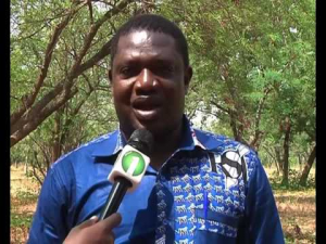


SARI’s Dr. Alhassan Lansah Abdulai


Call for Application

Hackathon for Environmental Sensors (Hardware) and IoT for Climate Services
Date: 19-23 November 2018 @ KNUST Kumasi Business Incubator, Kumasi

Background

TWIGA is a 4-year project (2019 – 2023) under EU Horizon2020 aimed to transform weather water data into value-added information services. It is made up of a consortium of 18 partners – 8 from Africa and 10 from Europe.

At the moment the products and services being considered some of which have been tested by TWIGA partners are in the Agriculture, Water, Energy, Disaster Response and Management, and Insurance sectors. For these products and services to be successful in the African market, often they need to be bundled and may require public-private partnerships (Bellagio-African-PPP-for-Climate-services 2017). For Agriculture, the following products are being considered: agriculture knowledge and information systems, crop monitoring (health and yield), site evaluation for crops, crop selection, and calendar, weather forecasting, fertilizer advice, Pest and disease management, sowing and planting advise, water use and irrigation advice, soil moisture assessment and modeling, soil nutrients assessment, salinity assessment, flood risk assessment, flood early warning system, drought risk assessment, drought monitoring, Extreme weather risk assessment, Extreme weather early warning, disaster monitoring, and impact assessment, agricultural (index) insurance, market access assessment and market information,  climate change modeling and monitoring, pasture, and water bodies identification and monitoring, forest and bushfire warning and monitoring, agricultural control, and compliance monitoring (Noort, 2018).

Objectives of the Hackathon

To foster involvement by young scientists and entrepreneurs, TWIGA will organize five hackathons; three on the development of geo-services at Strathmore (Kenya), TU Delft (Netherlands), and SAWS (South Africa), and two on sensor development at KNUST (Ghana), and TU Delft (Netherlands).

Because the hackathon will be partly funded by TWIGA, there has to be a realistic outlook toward a service. Therefore the objective of the hackathon in Kumasi will be to develop a viable product (environmental sensor and/or service) in 5 days in line with the TWIGA products and services outlined above.

Method

The SPRINT concept, more or less, which brings people in five days from concept to tested minimal viable product, will be used.

Requirements and Application Procedure

The call is open to only teams from Ghana. Similar hackathons will be organized in other parts of Africa later. The teams could be formed by individual persons, students, start-ups, companies, NGOs, or government organizations. Teams should have expertise in software and hardware development. All teams need to be physically present during the 5-day Hackathon in Kumasi.

All interested teams should send their application (2–page concept note, and the resume or CV of all proposed team members) on the environmental sensor(s) and/or IoT for climate service they intend to develop to info@twiga-h2020.eu with the words [TWIGA Hackathon in Kumasi] in the subject line of the email. The application should be submitted by 23.00hrs CET on 12 October 2018.

Start-ups that provided letters of support for the TWIGA project proposal are highly encouraged to apply as well as teams with women.

Prizes

5 Teams of not more than 3 people per team will be invited if they meet all the set requirements. There are prizes of  €1500, €1000, and €500 for numbers one, two, and three. These three finalists will be supported to take their ideas from conceptualization to full prototype ready to be tested on the market within 2 years.

The intellectual property rights of the winning prototypes developed during the course of the 5 days Hackathon will be shared between the developers and the TWIGA project.

Evaluation Criteria

At least one team member should have a University degree in the field of Engineering, Computer Science, Physics, or a related field with at least one (1) year of experience with hardware/software development.  A gender-balanced team will be an advantage. The main evaluation criteria will be the innovation and technology readiness level of the proposed product.

Logistics for the Hackathon

Accommodation (full board) will be provided if needed. Tickets for public transport to and from the venue will be reimbursed against receipts. Each team member will be required to present a national Identification card (e.g. Driving License, Passport, and Voters (ID) and a National Health Insurance Card or other forms of Health Insurance.

Program for the 5-Day Hackathon

Monday 19
Morning: Arrival/registration and an introduction of Teams (5 teams, 3 people (max) per team); Overview of concepts
Afternoon: Introduction and exercise LOOM

Tuesday 20
Morning: LOOM for specific applications, walkthrough, bottlenecks
Afternoon: Remix, improve the concept, and sketch.

Wednesday 21
Decide on the final design, rumble, and storyboard

Thursday 22
Build prototype

Friday 23
Test & learn
Award ceremony
Wrap-up, goodbye teams

For further information send an email to info@tahmo.org. Teams will be invited to the hackathon only after their proposal has been accepted and at least one member of the team interviewed via teleconference.

Sponsors for the Hackathon:

European Community’s Horizon 2020 Programme (2014-2020) under grant agreement n° 776691, Delft Global Initiative @ the Delft University of Technology, the Netherlands, Oregon State University, USA and the Kwame Nkrumah University of Science and Technology, Kumasi, Ghana.


Meteo Rwanda in partnership with the United Nations Development Programme (UNDP) challenged technocrats to design a climate early warning system. The challenge focused on using the Internet of Things (IoT) to develop a solution. And due to TAHMO’s experience in building early warning systems, we were invited to mentor the participants. Gilbert (TAHMO and SWC) and Dominique ( CEO SWC) participated.

In Uganda, TAHMO led the implementation of the Global Resilient Project that developed a Meteorological Early Warning system for fishers and the local population near Lake Victoria. An end-to-end solution was developed where weather information flows from the network of Automatic Weather Stations (AWSs) to big data analytics and all the way to millions of people via voice messages. TAHMO is also part of the Tanzania Urban Resilience Program (TURP) to offer a solution in disaster preparedness and emergency management through an early warning system. In this project, TAHMO installed AWSs and AWLs (Automatic Water Levels) in rivers and sites close to Dar Salaam. In Kenya, TAHMO is in a team building Integrated Real-Time Hydro-Meteorological Monitoring System in Nzoia River Basin. The goal is to have a functional flood early warning system.

Rwanda is in need of a similar early warning system. At the moment, information flow from Meteo Rwanda to people is not very effective. Meteo Rwanda generates predictions and then passes them to the Ministry of Disaster Management (MIDMAR) who details the information and then shares it with the public. This one-way flow of information is often slow and no way of holding any institutions accountable. The public wants a way of giving feedback to the institutions, to help them improve their services and better tailor the information.

But what does it take to design an early warning system? The UN international strategy for disaster reduction has identified risk knowledge, monitoring, and warning service, dissemination and communication, and response capacity as the key elements for an effective early warning system. So, when you start to think of developing a fully integrated early warning system, a number of questions come to mind. First is how data will be collected; which sensors do you use, will the data be reliable and does it meet the WMO standard? And how will streams of data from multiple sensors in multiple locations be handled? Then you will need to worry about how the data architecture will look like. How will you bulk datasets while continually maintaining the network running? You will then need to think about how data will be processed, information generated, and disseminated to people. You will also want to ensure all the various components are properly coordinated and working together.

10 groups participated in the challenge: Binary Earth, ECODEV, Hugs for Bugs, Dream Team, FORTENA and FARMATE, STES, HUBTZ team, CLINFONOT, and EcODEV. All the groups showcased unique solutions within the data chain. On dissemination of information, solutions ranged from the use of a web app, mobile app, USSD, SMS, and voice to share data with all stakeholders. Some groups included advanced features to allow quick sharing of information and sending alert warnings to physical alarm device that warns people in proximity of disaster, while other groups included using Machine learning algorithms to predict the likelihood of a disaster occurring. Other groups showcased how weather parameter data could be uploaded using low-cost electronic sensors.

On the sideline of the event, TAHMO participated in knowledge-sharing sessions with various government institutions among them RISA, MIDIMAR, Meteo Rwanda,
Rwanda Ministry of Agriculture and UNDP.

TAHMO is committed to establishing partnerships, sharing, and exchange of knowledge with institutions in the weather industry, with the goal of strengthening each other’s capacity.


**Written by Gilbert Mwangi Kamau


esnc15Prof. Dr. Nick van de Giesen, co-director of TAHMO, and Dr. Eugenio Realini won both as special prize winners in the University Challenge and as regional winners for the Netherlands in the 2015 European Satellite Navigation Competition (ESNC). Each year, the ESNC seeks services, products, and business innovations that use satellite navigation in everyday life. The prize pool in ESNC 2015 was valued at approximately 1 million Euros, which included cash awards, business incubation, business coaching, patent consulting, technical support, access to testing facilities, prototype development, publicity, marketing support, and much more. All of the winners were recognized on stage at a festive Awards Ceremony that took place on 20 October in line with the Satellite Masters Conference in Berlin, Germany.

The winning idea: GNSS (global navigation satellite system) monitoring of precipitable water vapor over East Africa using low-cost receivers.

African weather is poorly monitored, especially for forecast purposes. At the same time, African societies are vulnerable to extreme weather events. By far the most critical weather variable is rainfall. To make good predictions about rainfall, it is important to know how much water vapor the atmosphere contains. More water in the atmosphere means more rainfall. Traditionally, this amount of water is measured by weather balloons, but these are expensive and there are only a few regular launches over Africa. GNSS signals travel slightly more slowly through moist air than through dry air. A GNSS receiver can measure the extra delay caused by moisture in the atmosphere, even though the differences are very small. Today, even low-cost GNSS receivers are so accurate that they can measure these delays. The plan is to add these low-cost GNSS receivers to the stations of the TAHMO (Trans-African Hydro-Meteorological Observatory) network around Lake Victoria. TAHMO is building a network of 20,000 robust and cost-efficient weather stations across Africa. By adding GNSS/Galileo receivers, it will be possible to greatly improve rainfall predictions.

For more information about the competition and TAHMO’s contribution, check out the ESNC website here.


Aug21

Inhabitat.com is a weblog devoted to the future of design, tracking the innovations in technology, practices, and materials that are pushing toward a smarter and more sustainable future. Read the article ‘TU Delft Developing a Network Of 20,000 Weather Stations to Track Climate Change in Africa’ on this interesting website.

Photo credit: TAHMO


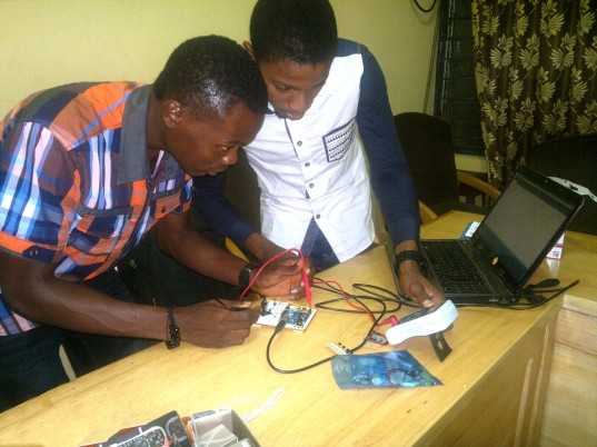
After a week of soldering, programming, and teamwork, a cheer went up when 21 sensors, brought in from all corners of Africa, came online and started submitting their measurements to the internet. The sensors were designed by the winners of the TAHMO Sensor Design Competition. Final Challenge of the TAHMO Sensor Design Competition held in Nairobi on 29 July [link].


Delta II

Categories: Technology
Comments: No

TU Delft researchers are using gift cards to measure rainfall. Their odd sensors must eventually provide insights into hydrology in Africa and on the TU Delft campus [link].


Delta I

Categories: Technology
Comments: No

Researchers at the Department of Water Management (Faculty of Civil Engineering and Geosciences) want to cover Africa with inexpensive weather stations made out of electronic gadgets, such as the Wii [link].