TAHMO

News

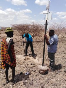
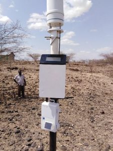
One of the challenges of the Ghana Meteorological Agency (GMet) is the availability of real-time weather data for its day-to-day activities such as daily weather monitoring and forecasting, climate monitoring, etc. It takes about a month for data from the manual observatories to get to the central collation point for digitization, quality control and archiving. GMet believes the deployment of automatic weather stations (AWS) is the best way to resolve this challenge. Following the partnership with the Trans-African Hydro-Meteorological Observatory (TAHMO), GMet has inched a step closer to achieving these results and improving its service delivery.
The TAHMO AWS network has complemented the GMet station network thereby improving the spatial resolution of the GMet data. This has helped GMet in generating gridded datasets of temperature and rainfall by merging the gauge data with satellite rainfall estimates and reanalyses data. In terms of data quality, the data have shown consistent correlation with the GMet observatories within close proximity of the TAHMO stations and for that reason used as reference stations for quality controlling the observed data.
It has also made available real-time data for weather monitoring and forecasting thereby improving the operational work of the forecast office.
Overall the TAHMO project has been of great benefit to both GMet and Ghana as a whole and this has reinforced the decision by GMet to roll out its AWS program.

**Written by Kwame Duah.

TAHMO has received two small business development grants under the SBIR program of the Netherlands government. The first grant concerns the development of an agronomic advice service for potato farmers in Rwanda. It is a cooperation between Severe Weather Consult, a Rwandan SME, and TAHMO. Potato farmers in Rwanda tend to spray a lot, especially to avoid a disease called Late Blight. It seems they are actually spraying too much and the service will provide advice as to when it is necessary to spray and when not. Information is provided by Apps4Agri, a Dutch SME, which provides input from their advisory system, while TAHMO/SWC provides the data concerning the climate to determine if the Late Blight pressure is high enough to warrant spraying.

The second project concerns a warning system for the onset of the rainy season in West Africa, particularly in Ghana’s northern regions. Often, rains occur early in the year which seems to be the start of the rainy season but are actually spurious rains that are followed by a drought of more than 10 days. When farmers sow after these first rains, they will lose their seed. By using a mix of TAHMO and satellite data, we can determine whether or not the real rainy season has started and warn farmers in case of a false start. This may also be used to build germination insurance. We will work together with the Ghana Agricultural Insurance Pool and Farmerline, two partners within the TWIGA project, and the Savanna Agricultural Research Institute (SARI). In this movie, Dr. Alhassan Lansah Abdulai of SARI explains the need for such a warning service. Full video here.


SARI’s Dr. Alhassan Lansah Abdulai

The School-2-School Team would like to highlight two schools as the winners of the S2S September Challenge. Namanga Mixed Secondary School and Kibisi Secondary School have been exceptional in their monthly TAHMO station cleaning and using the weather data in their classroom.

  • Namanga Mixed Secondary School has focused on temperature and wind speed & direction data from their TAHMO station. Students have learned how to calculate the daily mean temperature and the daily temperature range. Using the wind speed and direction data, students have learned how to draw wind rose to show the distribution of wind directions
  • Kibisi Secondary School has involved their students and geography club in cleaning their TAHMO Station. During a routine cleaning, students noticed that the rough middle surface (splash guard) was very dirty. They used their problem-solving skills and found a method to clean it using a toothbrush without interfering with the glass plate or the temperature sensor. The students have learned how important maintaining a clean weather station is to recording accurate results. The teacher in Charge Mr. Edalia Wycliffe uses the data in his classroom and has taught his students how to download the data from the School-2-School website. He uses the data in spreadsheet form to calculate mean, mode, range, and standard deviation and says using real data has enriched his classroom lectures

Gilbert attended the weather event indaba hosted by Deutsche Gesellschaft für Internationale Zusammenarbeit (GIZ) GmbH, the Make-IT in Africa, Agency for Business & Economic Development (AWE) and Strathmore University (@iLabAfrica) to explore the potential of integrated digital solutions in Agriculture. It aimed at exploring ways of using technology such as IoT and AI we aim to make life better for those who produce our daily food – the small-scale farmers and their families

Various participants from agricultural organizations, financial and insurance companies, tech start-ups, and government agencies were hosted. Gilbert demonstrated the TAHMO API and how it would contribute to improving the weather value chain in Africa.

At the end of the workshop, participants engaged in design thinking and developed possible solutions that agricultural communities, innovative start-ups, and tech communities can work together to bleach various challenges in the agriculture chain. On the sideline, Gilbert held meetings with the team of IBM Germany.


TAHMO hosted two workshops on user engagement one for the TAHMO internship and the other for users of the data on the 25th and 27th of August respectively. On the internship workshop, 18 graduates who recently joined our TAHMO internship program attended an induction meeting held at KMD, hosted by Gilbert and also facilitated by Frank( TAHMO CEO) and David Mburu (Director of Training school at KMD). Dirk V.O. Lubbe and Els Veenhoven also contributed to the workshop.

 It was an opportunity for interns to know how TAHMO operates, the challenges we want to solve, and how they would be involved. The internship program will challenge participants to solve a wide range of problems in the meteorological industry – from mapping users’ needs, big data management, station network management, school-to-school programs, and the development of business with weather data.  I am looking forward to reading lots of stories about what each one of them will be doing.

 Follow what the interns are up to on the link: https://sites.google.com/view/tahmointernship

On August 27th, TAHMO and KMS co-organized a workshop on Environmental sensor market research. over 50 participants ranging from Farmers, Universities, and private and public institutions attended.

TAHMO attended the 2nd RCMRD International Conference which was organized from the 15th to the 17th of August, 2018. Here, stakeholders from across Africa came together with ideas on how to fast-track applications for earth observations and geo-information technologies and discussed how to implement these into decision-making processes.

During the open-panel discussion, TAHMO shared its vision and experience on the importance of institutional collaboration.

The TAHMO Initiative regards training and education of both teachers and students of schools with a TAHMO station as a very crucial ingredient of the Initiative. This is done through the school2school program which is created to serve the important purpose of educating, training, and support with teaching and learning materials.

Students and Geography teachers of St. Paul’s SHS, Denu in the Volta Region of Ghana had an interactive session to understand TAHMO’s school2school program. The students joined Mr. Kwame Anhwere – the TAHMO regional coordinator – to carry out maintenance work and understand all the ins and outs of the weather station. This attracted students from other departments who found the session quite interesting.

During the sessions, the main discussion was about how the environment supports life and the importance to take good care of it. It was about the activities and responsibilities that individuals and governments have to minimize their impact on the environment. The last part of the discussion centered on the various sensors on the station, how they work, the parameters being measured, and how data could be accessed and visualized for lesson plans.

The students had the opportunity to see the real-time measurements when the station (logger) was connected to the computer as well as near real-time measurements online via the school2school.net platform. Some of them had the opportunity to check the data online.

The school expressed its appreciation and was happy to be among the selected schools in the country to host a TAHMO station.


**Written by Kwame Duah**

Turkana County is one of the counties in the former Rift Valley Province of Kenya. This is the second largest County in Kenya and it borders Uganda to the west and South Sudan and Ethiopia to the North.
15th January 2018 marked the start of a long journey of weather data collection by installing the first TAHMO Automatic Weather Station in the County, the first station was installed in Talent High School. TAHMO has up to now installed three Automatic weather stations in the County, Loima Boys High School, Talent High School, and Moi High School Kalokol.

On 5th July 2018, we received a ZL6 data Logger in Kenya. I decided to test the logger in areas with poor cellular network connectivity. My top priorities were Isiolo Meteorological offices where we have a TAHMO weather station and Loima Boys High School which is one of the sites in Turkana County. The first test was carried out at Isiolo Meteorological offices on 14th August 2018. The test was successful and the logger had a good network reception.

The station at Loima Boys High School had problems uploading data due to a weak cellular network. On 21st August 2018, I started a five-day journey to Turkana County, my aim was to bring the station at Loima Boys High School online again, test the ZL6 Logger and update the ATMOS firmware for all three stations in the county. I was very much committed to bringing the station at Loima online without moving it to a different location, I carried other local Sim-cards to the sites which I would use just in case the Vodafone Sim-Card failed. In my email conversation with Safaricom (network provider), they suggested we move the station to Lorughum where they have a 3G booster. So if all came to worse and the station failed completely, we would move the station to Turkana Girls High School which is near Lorghum 21 km away from Loima Boys High School. This means we would treat the weather data completely differently from that at Loima since these sites are far from each other.

Lodwar is the main town in the county, most people would come back to this town to spend their nights here after carrying out field activities in the remote villages. Loima Boys High School is located about 70km west of Lodwar town, this meant a 70 km drive on a large extensive semi-arid land. The best service you can do to yourself here is to take a lot of water. Sometimes we could drive for three hours before reaching Loima because the roads are covered by sand and the driver had to carefully choose the routes to follow otherwise the car could sink its tires into the sand.

The tricky part was crossing River Turkwel, here you have to get out of the car to reduce the weight of the car so that it doesn’t sink into the sand. At some point, we could push the car from behind to accelerate it so as to reduce the chances of it sinking. The best thing about crossing River Turkwel was that you meet several people who are also struggling to cross the river, you exchange ideas and some would tell you their mission in the county and their experience with the local communities.


We met a young boy who offers guidance to people who have issues crossing the river, he says, “If you want to successfully cross the river, you drive parallel to the flow of the river, in case you notice where the sand is well compressed and firm enough, tilt the tires slowly by slowly till you reach the other end.” This trick was successful for the four times we crossed the river.


The time we spend crossing the river gave me some ideas on how to deal with the local community. I was well prepared with everything I needed to bring the station at Loima Boys High School online, but the experience at the river gave me a very different view of things, how you deal with the community can help you find a solution quickly or make it completely impossible. So we decided to stop at Turkana Girls (where we would bring the station too if it completely failed to broadcast at Loima) to do some tests. Here we meet the gateman, I explained to him that we intend to move the station here because at Loima the network is very weak, I also told him that the site at Loima is built on higher ground within the school compound, and we really would wish to keep the station within Loima and not move it as far as Turkana girls. He listened to me carefully and he had this to say “If you really want to retain the station in Loima, you have to move it towards a lower ground within the compound, network in this region seems to be stable on the lower grounds than higher grounds.” I doubtingly agreed to this, so we drove to Loima, I removed the station from the middle pole and moved to the lower ground within the school compound, I carried out a communication test and it was successful.

I talked to the School principal and asked for permission to move the station to the lower ground about 100 meters from where it was as long it will not interfere with the School’s future infrastructural developments.


He agreed and we moved the station, I placed the ZL6 Logger and the EM60G logger on one pole. I set the upload frequency for the ZL6 Logger to be four data uploads per hour and that for EM60G to be one data upload per hour.


I am happy that the advice from the community members helped me bring the station online. I am also happy that I successfully completed a trip that involved making the right decisions very quickly and staying on top of everything

I hope that the existence of the TAHMO weather station in Loima Boys High School will be an eye-opener to the local community in Turkana County and a great contribution to the knowledge about climate change and a better understanding of the evolution of adaptations to semi-arid and other extreme conditions. This would give a chance for the Linking of traditional Beliefs on Climate Change Phenomena to Scientific Facts for Better Adaptation Strategies.

**Written by Victor Omoit